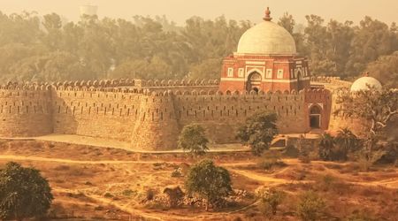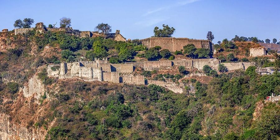
Standing at the confluence of the Banganga and Majhi rivers in Himachal Pradesh's Kangra Valley, the air carries the mineral tang of glacial water and the dry, sun-warmed scent of crumbling sandstone. The ramparts above you rise in irregular tiers, patched and repatched across three thousand years by hands speaking different languages and praying to different gods. Kangra Fort doesn't announce itself the way Rajasthani fortresses do, with clean geometric walls and proud cenotaphs. It sags. It leans. Whole sections have surrendered to gravity and earthquake. And that weathered refusal to disappear is precisely what makes it one of the most compelling military sites on the subcontinent.
This is India's oldest named fort, mentioned in texts dating to the fourth millennium BCE if you believe the Puranic tradition, and verifiably ancient even by conservative archaeological standards. It is also the largest hill fort in the Himalayas, sprawling across a rocky ridge that commands the valley below like a stone fist. Mughal emperors, Sikh maharajas, Gurkha warlords, and British administrators all planted their flags here — and the fort outlasted every one of them. What follows traces its layered history, its architecture, its legends, and what awaits you if you make the journey to the town of Old Kangra, twenty kilometers from Dharamsala.
Before Alexander's Shadow Reached the Valley
The Katoch dynasty claims Kangra Fort as their ancestral seat, and the Katoch claim is staggering in its ambition: they trace their lineage to the Trigarta kingdom mentioned in the Mahabharata. Historians handle this with appropriate caution, but what remains undisputed is that the fort appears in Alexander the Great's campaign records from 326 BCE, when it was already a formidable citadel controlled by the local hill raja. The Greek chroniclers called the kingdom Kathaioi. By any reckoning, the fortification on this ridge predates the common era by centuries.
The Katoch rulers governed a territory that straddled the trade routes connecting the Punjab plains with the high passes of what is now Ladakh and Central Asia. Kangra wasn't a backwater — it was a tollbooth. Salt, wool, horses, and spices moved through the valley, and whoever held the fort controlled the revenue. The early fortifications were likely rough stone enclosures, expanded generation by generation as wealth accumulated and enemies multiplied.
What makes Kangra's origins unusual among Indian forts is the continuity of its ruling family. The Katoch dynasty didn't vanish and reappear; they persisted, sometimes as kings, sometimes as vassals, across an unbroken line that some genealogists argue is the oldest surviving royal dynasty in the world. The fort passed out of their direct control multiple times, but the family kept returning, like tenants to a house they could never quite afford to abandon.
The Puranic and epic traditions layer the fort with mythological significance too. The Trigarta warriors who fought alongside the Kauravas in the Mahabharata are said to have ruled from this ridge. Whether or not you accept the historicity, the association tells you something about the fort's place in the regional imagination. By the time the first Muslim invaders arrived in the eleventh century, Kangra was already ancient — and already legendary.
Every Empire Left Its Fingerprints on These Walls
Mahmud of Ghazni arrived in 1009 CE with an army sharpened on a dozen previous raids across northern India, and Kangra Fort was his target for a specific reason: its temple treasury. He breached the defenses, looted an extraordinary haul of gold, silver, and jeweled idols, and departed. The fort didn't fall permanently — it was too remote, too strategically inconvenient for a Ghaznavid garrison. The Katoch rulers returned. This pattern repeated itself with almost comic regularity over the next eight centuries.
The Delhi Sultanate's Tughlaq and Lodi dynasties each claimed the fort at various points, installing governors who rarely lasted long in the hostile terrain. The real transformation came under Akbar, whose general forced the Katoch raja to submit in 1620 after a prolonged siege. The Mughals held the fort for over a century, adding their own architectural signatures to its bones. When Mughal power weakened, the Katoch rulers muscled their way back in — only to face the Gurkhas of Nepal, who seized Kangra in 1806 during their ambitious westward expansion.
The Gurkha occupation lasted just three years before Maharaja Ranjit Singh's Sikh forces laid siege and took the fort in 1809. Ranjit Singh recognized its strategic value and garrisoned it heavily. After the Anglo-Sikh Wars, the British acquired Kangra in 1846 and maintained it as a military post until the catastrophic earthquake of 1905 rendered it largely uninhabitable. Each conqueror added walls, repaired gates, built barracks — and each one eventually left. The fort collected their departures like geological strata, each layer visible if you know where to look.
A Ridge That Commands Everything Below It
Kangra Fort covers roughly four kilometers of ridgeline, a figure that surprises most visitors who arrive expecting a compact citadel. The approach road from Old Kangra town winds uphill through scrubby pine and rhododendron, and the outer walls emerge gradually, their mass obscured by the terrain until you're standing directly beneath them. The fort's footprint dwarfs Mehrangarh in Jodhpur and rivals Chittorgarh in sheer acreage, though it lacks the tourist infrastructure that makes those Rajasthani forts feel manageable.
The site's strategic logic is immediately legible. The ridge sits between two rivers — the Banganga to the south and the Neugal Khad to the north — creating natural moats on two sides. The only viable approach is from the east, where the slope is gentlest, and the builders compensated with the thickest walls and most elaborate gateways. From the highest point inside the fort, you can see the Dhauladhar range to the northeast and the Kangra Valley spreading west toward Pathankot. On clear winter mornings, the snowline glows pink before the sun clears the ridges.
The fort's scale also reflects its function as a self-contained city rather than a purely military installation. Inside the walls, there were palaces, temples, granaries, reservoirs, markets, and residential quarters for both the garrison and a civilian population. British survey records from the 1840s describe a functioning community within the fort, complete with metalworkers and weavers. The earthquake of 1905 emptied it, but the ruins still reveal the density of habitation — doorways opening onto narrow lanes, stone water channels carved into the bedrock, and the stumps of walls that once divided living quarters from storage rooms.
Where Mughal Arches Meet Rajput Stone
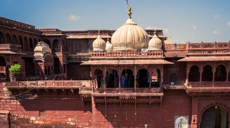
The fort's architectural character is a palimpsest, and reading it requires patience. The oldest surviving stonework — rough-hewn blocks fitted without mortar in the lower courses of the outer walls — probably dates to the medieval Katoch period, though precise dating remains contested. Above these foundations, you'll find Mughal-era additions: dressed stone, pointed arches, and the remains of jharokha-style balconies that wouldn't look out of place in Lahore. The Sikh period added thick bastions with cannon embrasures, built for a gunpowder age the original architects never anticipated.
The main entrance sequence is the fort's most architecturally legible feature. You pass through a series of gates — Darsani Darwaza, Ahini and Amiri Darwaza, Jehangiri Darwaza — each one a defensive checkpoint designed to slow and fragment an attacking force. The passages between gates are narrow and angled, forcing invaders into killzones where defenders above could fire or drop stones with impunity. The Jehangiri Darwaza, named for the Mughal emperor who oversaw its construction, still carries traces of painted plaster in its vaulted ceiling.
What catches the trained eye is how pragmatically each era's builders recycled their predecessors' work. Mughal masons didn't demolish Katoch walls; they built atop them or extended them outward. Sikh engineers widened existing bastions rather than constructing new ones. This isn't reverence — it's economy. Transporting stone up a ridge is punishing labor, and every dynasty recognized the value of what was already standing. The result is an architectural record that compresses roughly two millennia of Himalayan building practice into a single walkable site, though the earthquake damage makes some sections impossible to date with confidence.
Gods Who Survived the Plunder
Three temples inside the fort survive in various states of ruin, and their presence tells you something about Kangra's identity that the military history alone cannot. The Lakshmi Narayan Temple, the Ambika Devi Temple, and a smaller Jain shrine all occupied prominent positions within the fort walls — not tucked away in corners, but placed at the highest points, visible to the entire valley below. Worship and defense shared the same ground.
The Lakshmi Narayan Temple was the most significant of the three, and it was this temple's treasury that drew Mahmud of Ghazni across the Punjab in 1009. The original structure was heavily damaged during his raid and rebuilt multiple times afterward. What stands today is a modest shrine of no particular architectural distinction, but the site itself retains a charged atmosphere — pilgrims still come, leaving marigold garlands on stone that has been looted and restored more times than anyone can reliably count.
The Ambika Devi Temple is dedicated to the goddess Ambika, a form of Durga, and its surviving stonework includes carved panels depicting scenes from Hindu mythology that predate the Mughal presence. These carvings are among the fort's most valuable artistic artifacts, though erosion and earthquake damage have softened their details to the point where identification requires familiarity with the iconographic tradition. The Jain temple, smaller and less visited, speaks to the religious diversity of the fort's historical population — merchants and traders from Gujarat and Rajasthan who followed the trade routes into the valley and brought their faith with them. These weren't monumental temples by Khajuraho or Konark standards, but their persistence inside a military fortification is itself remarkable.
The Vault That Emptied Empires
Kangra Fort's treasury became the stuff of legend long before modern historians tried to separate fact from folklore. The accounts of Mahmud of Ghazni's raid describe a haul so enormous that the chronicler Al-Utbi claimed it took several days to catalog. The treasure allegedly included gold and silver idols, jeweled ornaments, and stores of coins accumulated over centuries of temple donations and trade taxes. Some historians speculate the temple treasury functioned as a regional bank, with merchants depositing valuables for safekeeping under the protection of both the gods and the fort's garrison.
The treasury's fame ensured that every subsequent invader arrived with the same expectation: that somewhere inside those walls, immense wealth lay hidden. The Tughlaqs searched. The Mughals searched. The Sikhs searched. The British conducted their own surveys. Whether any of them found anything significant beyond what Mahmud had already taken remains an open question. Local tradition insists that the Katoch rulers maintained secret vaults accessible only through passages known to the royal family, and that the earthquake of 1905 sealed these passages permanently beneath collapsed masonry.
There's no archaeological evidence to support the secret vault theory, but the persistence of the story across centuries and cultures is itself instructive. The treasury legend transformed Kangra Fort from a regional stronghold into a place of almost mythological significance, drawing attention and ambition from rulers who might otherwise have ignored a remote hill fort in the western Himalayas. The legend was, in effect, a strategic liability — it made the fort a target that its geography alone would not have justified. Wealth, real or imagined, shaped the fort's history as decisively as its walls and rivers.
Siege Tactics That Changed With the Centuries
The military history of Kangra Fort reads like a textbook on the evolution of South Asian warfare. The earliest recorded sieges relied on starvation — blocking supply routes and waiting for the garrison to surrender. The fort's water supply, drawn from the rivers below and stored in massive cisterns carved into the rock, made this strategy agonizingly slow for attackers. Some sieges lasted months. The Mughal siege of 1620, led by Nawab Ali Khan under Emperor Jahangir's orders, reportedly took over a year of sustained pressure before the Katoch defenders capitulated.
Gunpowder changed the equation but didn't simplify it. The fort's position atop a narrow ridge meant that artillery had to be hauled up steep approaches, and the angles of fire were constrained by the terrain. Sikh forces under Desa Singh Majithia, acting on Ranjit Singh's orders, besieged the Gurkha garrison in 1809 using a combination of cannon bombardment and negotiation. The Gurkhas eventually surrendered, less because the walls were breached than because their supply lines were severed and no reinforcements were coming from Kathmandu.
The British acquisition in 1846 came not through assault but through the Treaty of Lahore, which transferred Kangra along with other Sikh territories following the First Anglo-Sikh War. The British recognized the fort's strategic irrelevance in an age of railways and modern artillery, but they garrisoned it anyway — partly out of administrative habit, partly because the symbolism of holding the oldest fort in the hills mattered to their project of regional authority. By the time the earthquake struck in 1905, the garrison was more ceremonial than functional, a detail that may have saved lives but ensured the damage went largely unrepaired.
The Morning the Mountain Shook
At 6:19 a.m. on April 4, 1905, an earthquake measuring approximately 7.8 on the Richter scale struck the Kangra Valley. The epicenter was near the town of Kangra itself, and the destruction was catastrophic. Over 20,000 people died across the valley. The town of Kangra was essentially flattened. And the fort, which had survived three millennia of invasion, siege, and occupation, suffered damage from which it has never recovered.
The earthquake collapsed sections of the outer walls, brought down the upper stories of the palace complex, and shattered several of the bastions that Sikh engineers had reinforced less than a century earlier. The temples inside the fort were badly damaged; the Lakshmi Narayan Temple lost its shikhara tower. Cisterns cracked, and the internal water system — the fort's lifeline during sieges — was destroyed. Photographs taken by British surveyors in the weeks after the earthquake show a landscape of rubble and dust, with only the thickest lower walls still standing.
The British administration chose not to rebuild. The fort had already lost its military purpose, and the cost of reconstruction was deemed unjustifiable. The decision meant that what visitors see today is essentially the post-earthquake ruin, stabilized in places by the Archaeological Survey of India but not reconstructed. This gives Kangra Fort a rawness that restored monuments lack. You're not looking at a heritage theme park — you're looking at real damage, the kind that reminds you the Himalayas are young mountains, still rising, still shaking, and that everything built on their flanks is provisional.
Getting There, Getting In, and What to Bring
Kangra Fort sits roughly twenty kilometers south of Dharamsala, the Dalai Lama's adopted home and the town most travelers use as a base in the valley. The nearest railhead is Kangra Mandir station on the narrow-gauge Kangra Valley Railway, a slow, clattering line that runs from Pathankot and passes through some of the prettiest terrain in Himachal Pradesh. From Dharamsala, you can hire a taxi or take a local bus to Old Kangra town; the fort is a short walk uphill from the main road.
The fort is open daily from sunrise to sunset, and the Archaeological Survey of India charges a nominal entry fee — around 25 rupees for Indian nationals and 300 rupees for foreign visitors as of recent years, though these figures change without much warning. There is no audio guide and minimal signage, which means you'll get far more from the visit if you've read up beforehand or hire a local guide at the gate. The guides vary in quality, but even a mediocre one will point out features you'd walk past otherwise.
A few practical considerations worth noting:
- Wear sturdy shoes — the paths inside the fort are uneven stone and rubble, slippery after rain.
- Carry water; there are no functioning taps or shops inside the fort walls.
- Allow at least two to three hours for a thorough visit; the site is far larger than it appears from the entrance.
- The best light for photography arrives in the late afternoon, when the western sun catches the walls and the Dhauladhar range behind the fort turns gold.
- Visit between October and March for clear skies and comfortable temperatures; the monsoon months bring heavy rain and leeches on the approach paths.
The fort sees relatively few visitors compared to the Dalai Lama's temple complex in McLeod Ganj, which means you'll often have entire sections to yourself — a rare luxury at any Indian historical site.
Kangra Fort doesn't offer the polished experience of India's UNESCO-listed monuments. It offers something more difficult and more honest: the accumulated weight of continuous human occupation across three millennia, left largely as time and geology have shaped it. The fort forces you to do your own interpretive work — to read the walls, to trace the layers, to stand in a roofless temple and imagine the gold that once filled it and the earthquake that shook it empty. India has grander forts, better-preserved forts, more photogenic forts. But few places on the subcontinent compress so much contested history into a single ridgeline, and fewer still have the decency to let the ruins speak without dressing them up.
The next time someone tells you they've "done" Himachal Pradesh because they visited Manali and Shimla, you'll know what they missed — not a tourist attraction, but a place where empires went to prove themselves and the mountain eventually proved them all temporary.